ՆԱՍԱ-ն հրապարակել է Պլուտոնի ամենապարզ լուսանկարները (լուսանկարներ)

11:47 • 06.12.15

ՆԱՍԱ-ն հրապարակել է Պլուտոնի մակերեսի ամենապարզ լուսանկարները, որոնք մարդիկ հավանաբար տեսնում են տասնամյակների ընթացքում, գրում է CNN-ը:
 

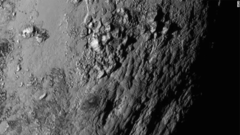
ՆԱՍԱ-ի New Horizons տիեզերանավի ստացած լուսանկարները ցույց են տալիս խառնարաններ, լեռներ և սառցադաշտային ռելիեֆներ 80 կիլոմետր լայնությամբ հատվածում:
 

Տիեզերանավը լուսանկարները ստացել է հուլիսին Պլուտոնին ամենամոտը թռչելու ընթացքում:
 

New Horizons-ը անցել է Պլուտոնի կողքով հուլիսին, բայց մոտ մեկ տարի կպահանջվի բոլոր լուսանկարները և տվյալները երկիր փոխանցելու համար:
 

Հետազոտողները սպասում են հաջորդ շաբաթ ավելի շատ լուսանկարների, որոնք ավելի շատ մակերևույթ ցույց կտան հնարավորինս բարձր որակով:
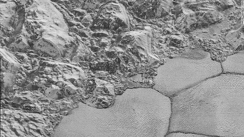
 

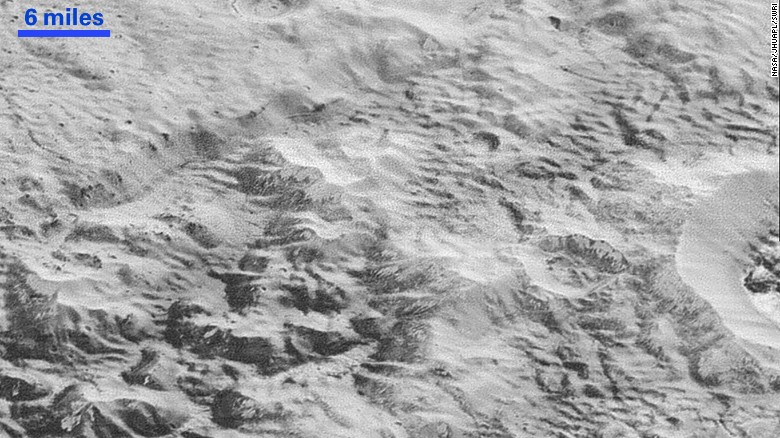
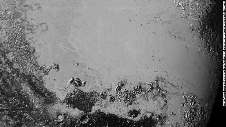
NASA has released the clearest images yet of the surface of Pluto. This photo shows the the mountainous shoreline of Sputnik Planum. "The mountains bordering Sputnik Planum are absolutely stunning at this resolution," said New Horizons science team member John Spencer of the Southwest Research Institute. <a  data-cke-saved-href="http://www.nasa.gov/image-feature/the-mountainous-shoreline-of-sputnik-planum" href="http://www.nasa.gov/image-feature/the-mountainous-shoreline-of-sputnik-planum" target="_blank">Read full caption.</a>

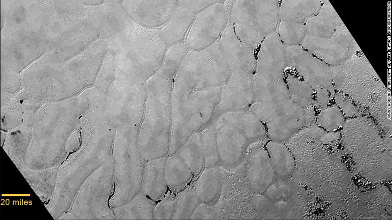
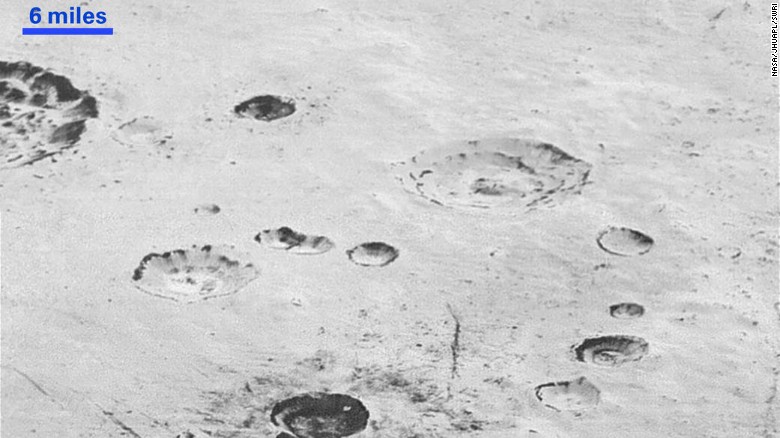
This image shows the layered interior walls of the planet's many craters. According to NASA, "layers in geology usually mean an important change in composition or event." However, NASA says the New Horizons team members do not know if they are seeing local, regional or global layering.<br />Most of the craters seen here lie within the 155-mile (250-kilometer)-wide Burney Basin. <a  data-cke-saved-href="http://www.nasa.gov/image-feature/plutos-layered-craters-and-icy-plains" href="http://www.nasa.gov/image-feature/plutos-layered-craters-and-icy-plains" target="_blank">Read full caption.</a>

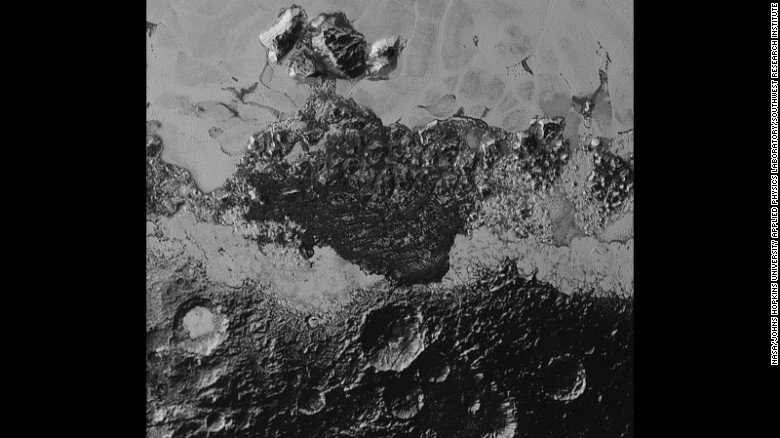
This image shows how erosion and faulting has sculpted Pluto's icy crust into rugged badlands. The prominent 1.2-mile-high cliff at the top is part of a great canyon system that stretches for hundreds of miles across Pluto's northern hemisphere, NASA says. <a  data-cke-saved-href="http://www.nasa.gov/image-feature/pluto-s-badlands" href="http://www.nasa.gov/image-feature/pluto-s-badlands" target="_blank">Read full caption.</a>

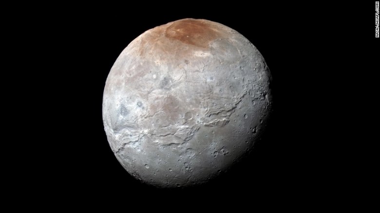
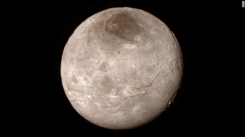
<a  data-cke-saved-href="http://www.nasa.gov/feature/pluto-s-big-moon-charon-reveals-a-colorful-and-violent-history" href="http://www.nasa.gov/feature/pluto-s-big-moon-charon-reveals-a-colorful-and-violent-history" target="_blank">Pluto's largest moon, Charon</a>, in seen in enhanced color in this image taken by NASA's New Horizons spacecraft. The space probe took the image just before it made its closest approach on July 14, 2015. The image combines blue, red and infrared images to best highlight the moon's surface features. Charon is 754 miles (1,214 kilometers) across. The image was released on October 1, 2015.

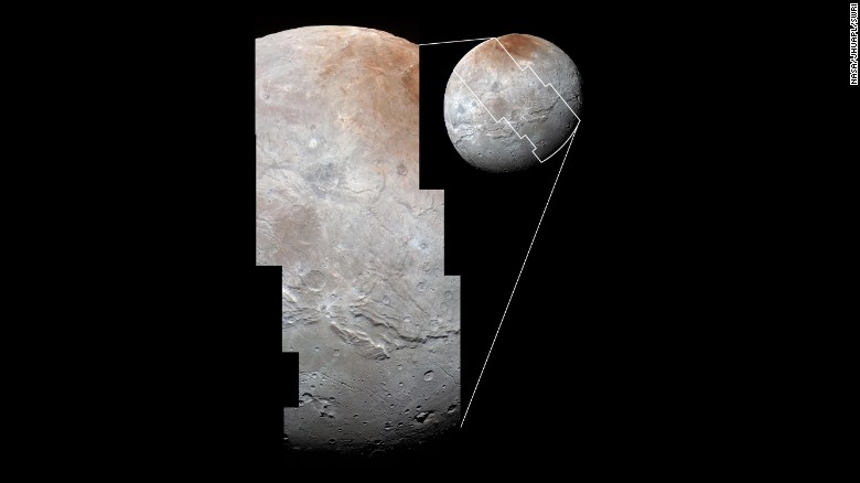
Images from two different instruments on New Horizons are combined in this photo to <a  data-cke-saved-href="http://www.nasa.gov/feature/pluto-s-big-moon-charon-reveals-a-colorful-and-violent-history" href="http://www.nasa.gov/feature/pluto-s-big-moon-charon-reveals-a-colorful-and-violent-history" target="_blank">show Charon's cratered uplands</a> at the top and a series of canyons. The bottom of the image shows rolling plains.

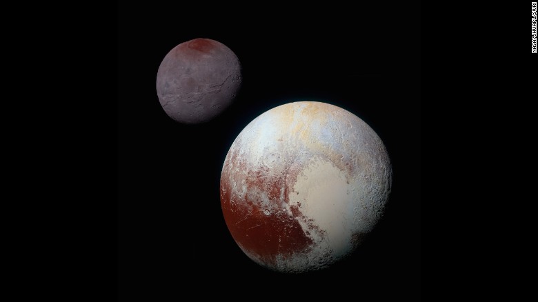
<a  data-cke-saved-href="http://www.nasa.gov/feature/pluto-s-big-moon-charon-reveals-a-colorful-and-violent-history" href="http://www.nasa.gov/feature/pluto-s-big-moon-charon-reveals-a-colorful-and-violent-history" target="_blank">This composite of enhanced color images</a> shows the striking differences between Pluto (lower right) and its largest moon, Charon (upper left). NASA says the color and brightness of the two worlds have been processed identically to allow for direct comparison. Pluto and Charon are shown with approximately correct relative sizes, but their true separation is not to scale.

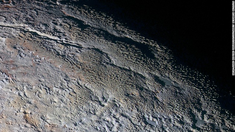
These photos show Pluto's variety of textures -- including what NASA calls "rounded and bizarrely textured mountains." The mountains are informally called the Tartarus Dorsa. This image shows about 330 miles (530 kilometers) of Pluto's terrain. It combines blue, red and infrared images taken by the space probe's Ralph/Multispectral Visual Imaging Camera. The images were taken on July 14, 2015, during the probe's flyby. They were released on September 24, 2015.

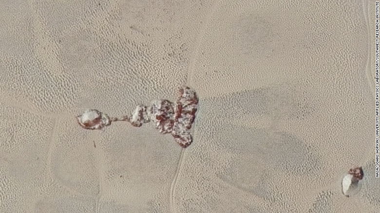
The photos taken by New Horizons just before its closest approach to Pluto on July 14, 2015, are the sharpest images to date of Pluto's varied terrain. This high-resolution image reveals details of two ice mountains. The image spans 75 miles (120 kilometers) of Pluto's surface.

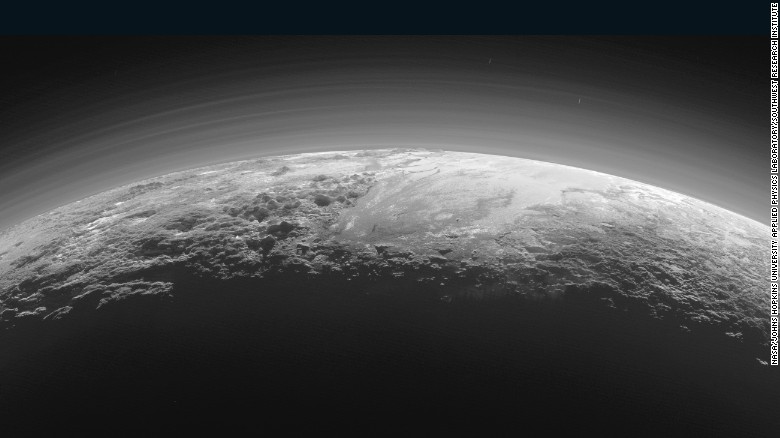
This image of the surface of Pluto was taken just 15 minutes after NASA's New Horizon spacecraft made its closest approach to the icy planet on July 14, 2015. As it looked toward the Sun, the spacecraft's camera captured more than dozen thin layers of haze in Pluto's atmosphere, at least 60 miles (100 kilometers) above the surface. The photo was downlinked to Earth on September 13, 2015.

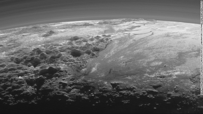
This image of Pluto's icy and mountainous landscapes was taken from a distance of 11,000 miles (17,700 kilometers). "This image really makes you feel you are there, at Pluto, surveying the landscape for yourself," said New Horizons Principal Investigator Alan Stern, of the Southwest Research Institute in Colorado.

This picture is a synthesis of new high-resolution images downlinked from New Horizons. The broad icy plains have been nicknamed Sputnik Planum. This image is from a perspective above Pluto's equatorial area. Astronomers began downlinking a data dump from the space craft over Labor Day weekend, September 5 to 7.

Scientists say that what looks like mountains could be huge blocks of frozen water suspended in frozen nitrogen. On the new photos, taken on July 14 and released on September 10, a pixel is 400 meters (440 yards). New Horizons' closest pass by Pluto took it about 50,000 miles from the surface.

Pluto's landscape has lots of variety -- plains, mountains, craters, and what looks like they might be dunes. The smallest details on the photos are about 0.5 miles wide. The area with the craters is ancient, scientist say. The smooth frozen planes are relatively young.

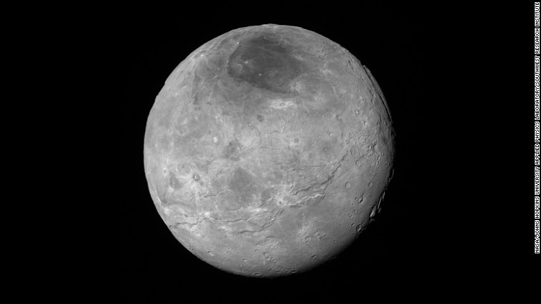
Just before its closest approach to Pluto on July 14, NASA's New Horizons spacecraft snapped this photo of Charon, Pluto's largest moon. The photo was shot at a distance of 290,000 miles away.  Charon's north pole region is markedly dark. This photo was released on September 10.

This new image of Pluto is stunning planetary scientists. It shows the small world's atmosphere, backlit by the sun. NASA says the image reveals layers of haze that are several times higher than predicted. The photo was taken by the New Horizons spacecraft seven hours after its closest approach to Pluto on Tuesday, July 14. New Horizons was about 1.25 million miles away from Pluto at the time.

Images taken of Pluto's heart-shaped feature, informally named "Tombaugh Regio," reveal a "vast, craterless plain that appears to be no more than 100 million years old," NASA said on Friday, July 17. The frozen region "is possibly still being shaped by geologic processes." NASA's New Horizons spacecraft was launched in 2006 and traveled 3 billion miles to the dwarf planet.

Close-up images of a region near Pluto's equator revealed a giant surprise: a range of youthful mountains. NASA released the image on Wednesday, July 15.

Remarkable new details of Pluto's largest moon, Charon, are revealed in this image released on July 15.


ՆԱՍԱ-ն հրապարակել է Պլուտոնի ամենապարզ լուսանկարները (լուսանկարներ)